Vehicles:Bombardier Bombardier Portland, Siemens SD-660 and Siemens S70
Sources: Wikipedia, nycsubway.org

| Portland MAX | ||
|
The Portland Metropolitan Area Express or MAX is a light rail system
serving the metropolitan area of Portland, Oregon with four lines, Blue, Green,
Red and Yellow. It consists basically of a main east-west route centered at downtown Portland
(Pioneer Square)
and several north-south spurs. The Blue line traverses the full main route and the
other lines share portions of it and continue into their individual spurs. The east-west route
serves suburbs in these respective directions from dowtown and the spurs serve north and south suburbs and
the airport. The Pioneer Courthouse Square functions as a hub for all four lines.
MAX is owned and operated by TriMet, the Portland metro area's Transit Authority. Vehicles:Bombardier Bombardier Portland, Siemens SD-660 and Siemens S70 Sources: Wikipedia, nycsubway.org |
| |
| Rights of Way In the downtown area MAX operates in restricted mixed traffic zones. Elsewhere, it runs in exclusive rights of way. The east and west segments make much use the rights of way of former railroads. The spurs mostly use highway medians or roadside rights of way. Major engineered paths are the Steel bridge across the Willamette river and the deep tunnel and station at Washington Park west of downtown. |
| Mixed Traffic Sections MAX LRV traffic through downtown Portland is through two sets of paired one-way streets, one north/south set and one east/west set. Although Portland calls them "tansit malls", they do not meet the classic definition of traffic restricted to public transportation and emergency vehicles. One-way auto traffic is allowed on one lane of each street, and some sections also have an auto parking lane. | |
 |
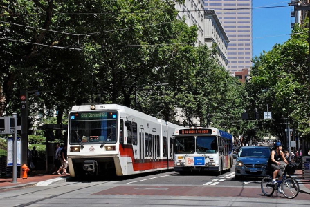 |
| On Portland "Transit Mall" at 6fh Avenue Photo Source: Wikipedia, Author: © M.O. Stevens |
On Portland "Transit Mall" at 5fh Avenue Photo Source: Wikipedia, Author: © Steve Morgan |
| Elevated Section The Steel Bridge across the Williamette river was built in 1912 for railroad and auto traffic, including streetcars. The bridge has two levels. The upper one is used for all four MAX lines and auto traffic in restricted lanes. The lower level is used by Amtrak passenger trains. | Underground Section The MAX Washington Park station is in the Robertson Tunnel, which was built in 1998 through the Tualatin Mountains west of Portland, in order to avoid a very steep climb for the LRV's. This is the deepest underground station in the United States. It is equipped with four high speed elevators to carry MAX passengers to/from the surface. It is used by the Blue and Red lines. |
 |
 |
| On Steel Bridge Photo Source: Wikipedia, Author: © Steve Morgan |
Washington Park Station in Robertson Tunnel Photo Source: Wikipedia, Author: Ajbenj |
| Railroad Rights of Way | |
| Much of the right-of-way used at the western end of the Blue line reused a route first built for the Oregon Electric Railway. The Hillsboro Central/3rd Avenue Transit Center MAX station is located at a former stop of the old Oregon Electric route. This is reflected in the station design. | The eastern Blue line through Gresham follows an old electric interurban right-of-way, once known as the Mt. Hood Railway, including the East 172nd Avenue station. The tracks through this section often use the traditional tie-and-ballast style. Many of these stations have a similar design with staggered side platforms on either side of the cross street. |
 |
 |
| Blue Line Hillsboro Central/3rd Avenue Photo Source: The Toromto LRT Info. Page, Author: © Calvin Henry-Cotnam |
Blue Line East 172nd Avenue Station Photo Source: Wikipedia, Author: © Steve Morgan |
| Yellow Line Road Side Section The MAX Yellow Line runs north-south between the Portland Expo Center and Portland State University. It is also known as the Interstate MAX because the majority of the line runs along Interstate Avenue. |
Green Line Highway Median or Side Section Much of the north-south segent of the MAX Green Line parallels the I-205 highway. A number of the stations are located on the median or the side of the highway. |
 |
 |
| Yellow Line Along Interstate Avenue Photo Source: Wikipedia, Author: Nick Schillaci (Alphalife) |
Green Line Clackamas Station Photo Source: Wikipedia, Author: © Steve Morgan |
| Station Design and Settings | ||
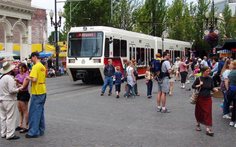
| The Pioneer Courthouse Square functions as a hub for the Max system, accessed by all four lines. The station on the south edge of the plaza, shown below, is decorated with a set of columns. | The Skidmore Fountain stop on the Blue and Red lines serves the 1888 Skidmore Fountain and surrounding historic buildings as well as the Saturday Market held at this location. | |
 |  |
|
| Pioneer Courthouse Square South Edge Station Photo Source: Light Rail Central, Author: © Clinton Wood | Skidmore Fountain and Saturday Market Photo Source: Light Rail Photos, Author: © Darrell Clarke |
|
| Return to Implementation Examples Return to Main Page |